






By Mamun Kabir
The devastating floods that swept across Bangladesh in July 2026 were not merely another seasonal disaster. They were a stark reminder that climate change, environmental degradation, and weak river governance are converging to create a new era of hydrological crises. What unfolded across the country’s south-eastern, north-eastern, and northern districts should not be viewed simply as an extreme weather event; rather, it should be understood as a warning that Bangladesh’s existing flood management strategies are increasingly inadequate in the face of a changing climate.
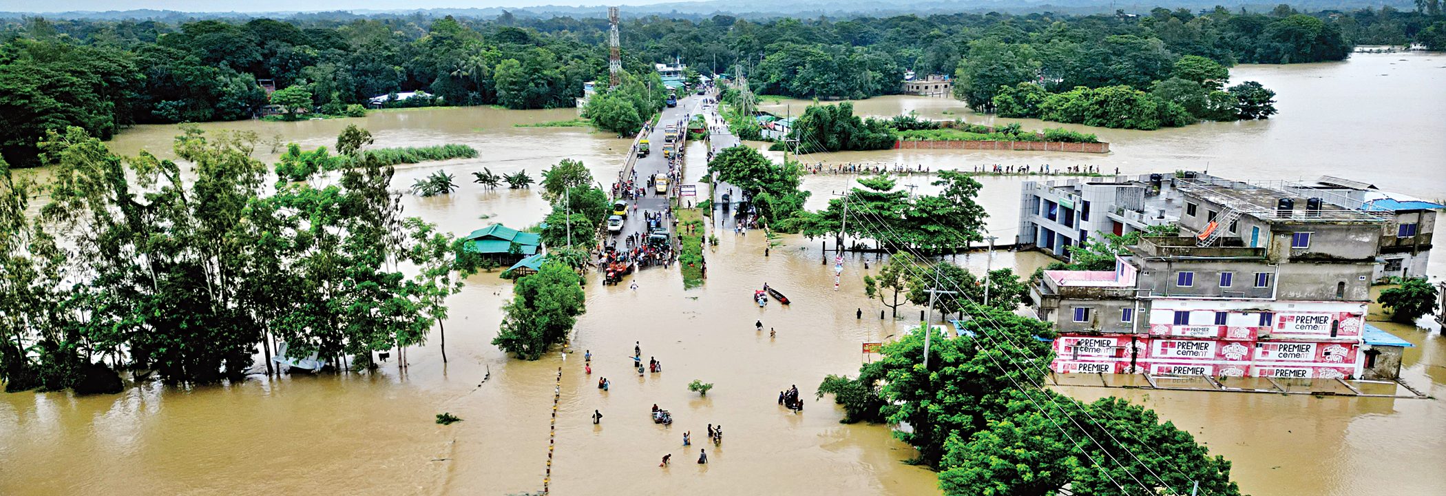
According to government agencies and reports published by national media, the July 2026 floods affected more than five million people across Bangladesh’s south-eastern, north-eastern, and northern regions. The disaster caused significant loss of life, inundated tens of thousands of hectares of agricultural land, damaged hundreds of kilometres of roads and bridges, destroyed thousands of fish ponds, and disrupted livelihoods, transportation, education, and essential public services. Among the worst-affected districts were Chattogram, Cox’s Bazar, Rangamati, Bandarban, Kurigram, Sylhet, Sunamganj, Moulvibazar, and Netrokona, illustrating the nationwide scale and diversity of flood impacts.
The economic consequences of the July 2026 floods extend well beyond the immediate destruction of infrastructure and property. Agriculture, fisheries, livestock, transport, tourism, and local businesses all suffered substantial losses. Flooded cropland threatens seasonal food production, while damage to roads and bridges disrupts supply chains and increases transportation costs. Small farmers, fishers, and informal workers often lose both their productive assets and income simultaneously, making recovery particularly difficult. Recurrent climate-induced disasters also place increasing pressure on government budgets through emergency response, rehabilitation, and reconstruction expenditures. As floods become more frequent and intense, they pose a growing challenge to Bangladesh’s long-term economic growth, food security, poverty reduction, and sustainable development.
While rural flooding often receives greater attention, urban flooding has become an equally pressing challenge. Cities such as Dhaka, Chattogram, Sylhet, and Khulna increasingly experience severe waterlogging following intense rainfall events. Rapid and often unplanned urbanization, encroachment on wetlands and canals, inadequate drainage infrastructure, and the expansion of impervious surfaces have significantly reduced the natural capacity of cities to absorb stormwater. Climate change is amplifying these vulnerabilities by increasing the frequency of short-duration, high-intensity rainfall events. Building climate-resilient cities therefore requires restoring urban waterways, protecting wetlands, modernizing drainage systems, and integrating climate risk assessments into urban planning.
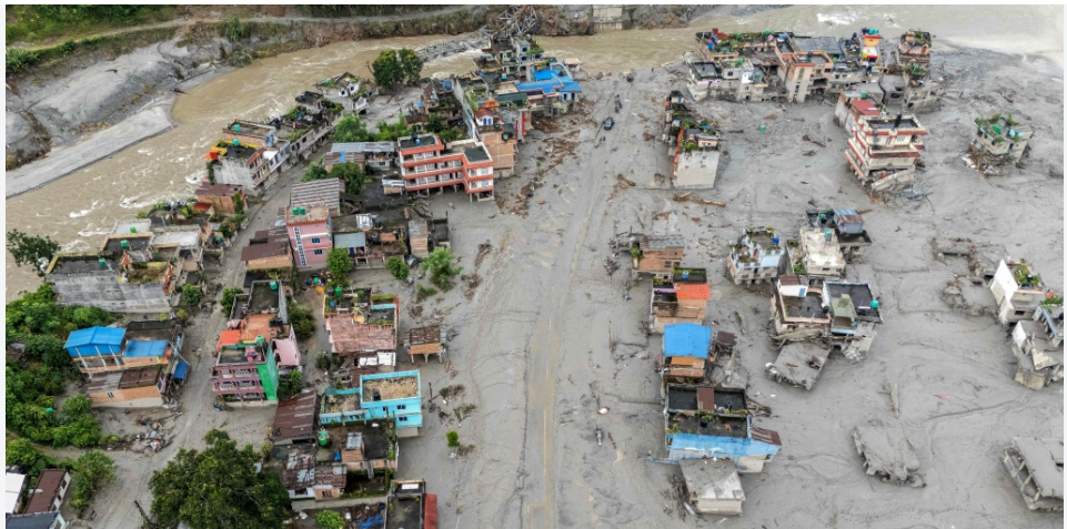
The human cost was severe. Lives were lost, thousands of hectares of cropland were submerged, roads and bridges collapsed, fish farms were destroyed, and communication networks were disrupted. In the Chittagong Hill Tracts, the disaster was compounded by landslides, while in the northern floodplains, embankment failures and riverbank erosion intensified the suffering of already vulnerable communities.
Nearly 92 percent of the catchment area of the Ganges–Brahmaputra–Meghna (GBM) Basin lies outside Bangladesh, making the country highly dependent on upstream hydrological conditions. Consequently, effective flood management cannot be achieved through national measures alone. Bangladesh should strengthen regional cooperation with neighbouring countries by promoting real-time hydrological data sharing, joint flood forecasting, coordinated reservoir management where applicable, and integrated river basin planning. Moving from fragmented water management to basin-wide governance would improve flood preparedness, enhance water security, and reduce disaster risks across the entire region. Rivers transcend political boundaries, and sustainable flood management must therefore be based on cooperation rather than unilateral action.
However, natural factors tell only part of the story. Human interventions have significantly amplified flood risks. Unplanned roads, embankments, and urban development have obstructed natural drainage pathways. Rivers, canals, wetlands, and floodplains that once stored and conveyed excess water have been encroached upon or filled. Siltation has reduced the carrying capacity of many rivers, while hill cutting and deforestation have accelerated runoff and increased the likelihood of landslides. These cumulative changes have transformed heavy rainfall into catastrophic flooding.
The devastating floods that struck Bangladesh in July 2026 underscore the growing influence of climate change on the country’s hydrological regime. While seasonal flooding has long been a defining feature of Bangladesh’s riverine landscape, recent flood events have become markedly more frequent, intense, and destructive due to the combined effects of global climate change, environmental degradation, and increasing pressure on river systems. The July 2026 floods were therefore not an isolated natural disaster but part of an emerging pattern of climate-induced extreme weather events across South Asia.
Over the past several years (2023–2026), Bangladesh has experienced a noticeable increase in the frequency and intensity of extreme monsoon rainfall, particularly across the north-eastern and south-eastern regions. According to meteorological observations, cumulative rainfall during July 2026 reached approximately 800- 1,300 mm in the north-eastern districts and 900- 1,400 mm in parts of the south-east. In several locations, more than 300- 400 mm of rainfall was recorded within a single 24-hour period, exceeding normal monsoon averages and triggering widespread flash floods, landslides, and prolonged waterlogging.
One of the principal climate-related drivers behind these extreme rainfall events is the warming of the Bay of Bengal. Rising sea surface temperatures have increased atmospheric moisture content, enabling monsoon systems to carry larger volumes of water vapour. Consequently, when these moisture-laden air masses encounter the hilly terrain of northeastern India and southeastern Bangladesh, they generate exceptionally intense precipitation. Scientific evidence indicates that a warmer atmosphere can retain approximately 7 percent more moisture for every 1°C increase in temperature, thereby increasing the likelihood of short-duration, high-intensity rainfall events.
The July 2026 floods were further exacerbated by heavy upstream rainfall across the Indian states of Meghalaya, Assam, Tripura, and Mizoram. The resulting hill runoff rapidly entered Bangladesh through numerous transboundary rivers, including the Surma, Kushiyara, Someshwari, Teesta, Dharola, Dudhkumar, Brahmaputra, Karnaphuli, Halda, Sangu, Matamuhuri, and Reju river systems. As Bangladesh lies at the downstream end of the Ganges-Brahmaputra-Meghna (GBM) Basin, which drains one of the largest river basins in the world, extreme precipitation occurring outside its borders can quickly translate into severe flooding within the country. Climate change is expected to increase both the frequency and intensity of such upstream rainfall events, thereby amplifying downstream flood risks.
Climate change, however, acts as a force multiplier rather than the sole cause of flooding. Its impacts interact with existing environmental and developmental challenges. River siltation, wetland encroachment, floodplain occupation, deforestation, hill cutting, and poorly planned infrastructure have significantly reduced the natural capacity of rivers and wetlands to absorb and convey floodwaters. Consequently, rainfall events that might once have caused localized flooding now result in widespread inundation, prolonged waterlogging, riverbank erosion, and extensive damage to settlements, agriculture, transport infrastructure, and livelihoods.
The Intergovernmental Panel on Climate Change (IPCC) has consistently warned that South Asia is among the region’s most vulnerable to climate-induced increases in extreme precipitation. Similarly, the World Meteorological Organization (WMO) has reported that rising global temperatures are intensifying the global hydrological cycle, leading to more frequent heavy rainfall events, flash floods, and cascading disasters. Bangladesh’s geographical location at the confluence of three major transboundary river systems and adjacent to the warming Bay of Bengal makes the country particularly susceptible to these evolving climatic risks.
The July 2026 floods therefore represent more than a seasonal monsoon disaster; they illustrate the emergence of a new climate reality for Bangladesh. Future flood management strategies can no longer rely solely on historical flood patterns. Instead, national planning must incorporate climate projections, strengthen flood forecasting and early warning systems, promote integrated transboundary river basin management, restore rivers and wetlands, and invest in climate-resilient infrastructure and ecosystem-based adaptation. Without such measures, the frequency, severity, and socio-economic consequences of extreme flood events are likely to increase significantly in the coming decades, posing serious threats to Bangladesh’s sustainable development and climate resilience.
Bangladesh has made notable progress in disaster preparedness, yet adaptation requires far greater investment than emergency relief alone. Climate finance should prioritize long-term resilience by supporting river restoration, wetland conservation, flood-resilient infrastructure, climate-smart agriculture, and community-based adaptation initiatives. As one of the country’s most vulnerable to climate change despite contributing only a negligible share of global greenhouse gas emissions, Bangladesh has a strong case for enhanced international financial and technical support under the Paris Agreement, including access to adaptation finance and the Loss and Damage Fund. Investing in resilience today is considerably less costly than repeatedly rebuilding communities after each major disaster. A transformation is now urgently required for flood governance.
First, flood forecasting and early warning systems must become faster, more localized, and better integrated with community-based response mechanisms. Timely warnings save lives only when communities receive, understand, and trust the information.
Second, river basin management must replace fragmented administrative approaches. Rivers do not recognize political boundaries. Bangladesh must strengthen cooperation with neighbouring countries to improve data sharing on rainfall, reservoir releases, and upstream river conditions while promoting integrated management of shared river basins.
Third, restoring rivers, canals, wetlands, and natural floodplains should become a national priority. These ecosystems function as natural buffers that reduce flood peaks, recharge groundwater, and support biodiversity. Protecting them is considerably more cost-effective than repeatedly rebuilding damaged infrastructure.
Fourth, climate resilience must become central to infrastructure planning. Roads, embankments, bridges, drainage systems, and urban expansion should be designed with future climate scenarios in mind rather than historical averages.
Finally, post-disaster recovery should go beyond humanitarian relief. Farmers, fishers, and small businesses require timely financial assistance, agricultural rehabilitation, livelihood support, and access to safe water and healthcare to prevent disasters from becoming long-term development setbacks.
The floods of July 2026 should mark a turning point in Bangladesh’s climate policy. The challenge is no longer simply managing seasonal floods; it is adapting to an era of increasingly volatile hydrological extremes driven by climate change and environmental degradation.
Bangladesh has repeatedly demonstrated resilience in the face of adversity. However, resilience alone will not be sufficient in the years ahead. What is required is a comprehensive strategy that combines climate science, ecosystem restoration, integrated river basin governance, resilient infrastructure, and regional cooperation.
The next major flood is not a question of if, but when. The decisions taken today will determine whether future floods become national catastrophes or manageable natural events. July 2026 has delivered a clear message. The time to act is now.

Author: Mamun Kabir is an Environmental and Human Rights Activist in Bangladesh